Aldenham 31A
This path is part of the Hertfordshire Way.
This path was completely unusable.
It was unusable due to the actions of the underlying landholders.
It was also unusable due to the inactions of our Highway Authority.
This path has a long history. This page is just a tiny bit of that history.
The Friends of the Hertfordshire Way, the Ramblers' Association, the Open Spaces Society, the Radlett Society, Aldenham Parish Council all were involved.

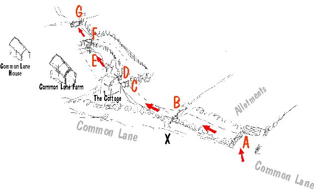
A Entrance by
allotments. A to B was part of the path on first definitive map, later (current)
map starts at B.
B Top of the sloped drive from A to
B. Steep near-vertical 6 ft drop at B to the road at X.
C Double
gate, no authorisation that we know of.
D Single latched gate authorised by
County Hall, purportedly under Highways Act 80 s147, but we believe that Act was
not applicable here.
E Garden planted across path,
subject of court action by Hertsmere Borough
F Another unauthorised gate
G Gate
The Definitive Statement for this path, which is conclusive in a court of law as to position, says that the path commences from Common Lane at the N tip of allotment gardens. This is point B above or rather point X, but point A is also on the northern boundary and could also be the 'N tip' We don't care in the short term, but we do care that we can use neither.
The occupier of The Cottage denied that the path goes to Common Lane, despite the conclusiveness of the definitive statement. Hertfordshire County Council, in a complete abrogation of their Statutory Duty, refused to make the route at X safe (by steps or whatever) or remove the barbed wire across it, whilst not asserting B to A either. Thus knowingly denying the public any access to this bit of the Hertfordshire Way.
Path users were exceedingly cross at this, our members were accosted and obstructed
and the path became effectively closed and naturally we looked to County for
help. But we looked in vain.
We first formally complained about problems on this path in 1994, eight years
ago. It got worse. We did not see why we should be
denied this path for year after year, nor why walkers on the Hertfordshire Way
should have to live with such risk and confusion.
From our viewpoint it looked like County was siding with the landholders, contrary
to their express duty [Highways Act 130 and Send]. Why did they
not open up this path on either the current or the earlier definitive route,
why did they not fulfil their duty to signpost it or to waymark it fully,
why did they they tolerate unlawful signs, unlawful gates, and continuing
intimidation of the public by people and dogs?
26 Feb 2002. We received notice from County that they have taken a
formal decision to make an order to the effect that the route A to B be added to
the definitive map and that the current path junction with Common Lane at point
X be deleted. They didn't do the deletion bit, but they made the order
eventually and we spoke at the inquiry and the government inspector decided in
our favour.
Eventually the obstructions started to be removed (though the police had to be called) but at the end of 2005 there are still three gates to be enforced.
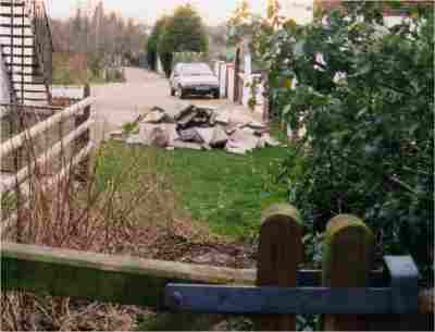
Two views of part of this path
 |
Looking south west from point C or D. County Hall referred to these paving slabs as 'a small pile of rubble' and in no way an obstruction. If only our problems were now as minor as this. The dog which lives in this part of the path is what is now quaintly called a German Shepherd. |
|
 |
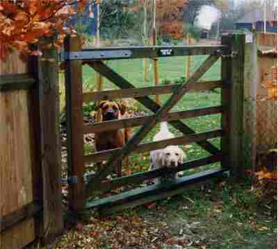
Looking along the path from point D towards F and G.
Notice the trees then (1998) planted on the path (some have since gone). Waymarks absent, the sign says 'beware of the dog'. The Rhodesian Ridgeback was only a puppy then.
|